HTTP 200 OK
Allow: GET, POST, HEAD, OPTIONS
Content-Type: application/json
Vary: Accept
{
"next": "https://mpr.acdh.oeaw.ac.at/apis/api/entities/place/?format=api&limit=50&offset=50&ordering=-notes",
"previous": null,
"count": 2006,
"limit": 50,
"offset": 0,
"results": [
{
"url": "https://mpr.acdh.oeaw.ac.at/apis/api/entities/place/14234/?format=api",
"id": 14234,
"name": "Lifes",
"review": false,
"start_date": null,
"start_start_date": null,
"start_end_date": null,
"end_date": null,
"end_start_date": null,
"end_end_date": null,
"start_date_written": null,
"end_date_written": null,
"status": "",
"references": "Angaben über den Ort nach Temiz.",
"notes": "zerstörter Ort im Komitat Somogy (Ungarn).",
"published": false,
"lat": null,
"lng": null,
"source": null,
"kind": null,
"text": [
{
"id": 2358,
"label": "ID: 2358",
"url": "https://mpr.acdh.oeaw.ac.at/apis/api/metainfo/text/2358/"
}
],
"collection": [
{
"id": 17,
"label": "QHOD",
"url": "https://mpr.acdh.oeaw.ac.at/apis/api/metainfo/collection/17/"
}
],
"sameAs": [
"https://mpr.acdh.oeaw.ac.at/entity/14234/"
]
},
{
"url": "https://mpr.acdh.oeaw.ac.at/apis/api/entities/place/15857/?format=api",
"id": 15857,
"name": "Serembek",
"review": false,
"start_date": null,
"start_start_date": null,
"start_end_date": null,
"end_date": null,
"end_start_date": null,
"end_end_date": null,
"start_date_written": null,
"end_date_written": null,
"status": "",
"references": "",
"notes": "Village situated between the \"porte Trajana\" and Pazardzhik, probably no longer existing today. Also known as Saram Beik in the 19th century: https://books.google.at/books?id=b95CCurYfsEC&pg=PA346&dq=saram+beik&hl=de&sa=X&ved=2ahUKEwiP_eKM5NX7AhWtgv0HHa0bBikQ6AF6BAgLEAI#v=onepage&q=saram%20beik&f=false",
"published": false,
"lat": null,
"lng": null,
"source": null,
"kind": null,
"text": [
{
"id": 3136,
"label": "ID: 3136",
"url": "https://mpr.acdh.oeaw.ac.at/apis/api/metainfo/text/3136/"
}
],
"collection": [
{
"id": 17,
"label": "QHOD",
"url": "https://mpr.acdh.oeaw.ac.at/apis/api/metainfo/collection/17/"
}
],
"sameAs": [
"https://mpr.acdh.oeaw.ac.at/entity/15857/"
]
},
{
"url": "https://mpr.acdh.oeaw.ac.at/apis/api/entities/place/15345/?format=api",
"id": 15345,
"name": "Tekirdağ",
"review": false,
"start_date": null,
"start_start_date": null,
"start_end_date": null,
"end_date": null,
"end_start_date": null,
"end_end_date": null,
"start_date_written": null,
"end_date_written": null,
"status": "distinct",
"references": "",
"notes": "This place has been misidentified as Rhodos, but fixed.",
"published": false,
"lat": 40.9781,
"lng": 27.51101,
"source": null,
"kind": {
"id": 231,
"label": "https://www.geonames.org/ontology#P.PPLA",
"url": "https://mpr.acdh.oeaw.ac.at/apis/api/vocabularies/placetype/231/",
"parent_id": null
},
"text": [
{
"id": 3126,
"label": "ID: 3126",
"url": "https://mpr.acdh.oeaw.ac.at/apis/api/metainfo/text/3126/"
}
],
"collection": [
{
"id": 1,
"label": "Default import collection",
"url": "https://mpr.acdh.oeaw.ac.at/apis/api/metainfo/collection/1/"
},
{
"id": 17,
"label": "QHOD",
"url": "https://mpr.acdh.oeaw.ac.at/apis/api/metainfo/collection/17/"
}
],
"sameAs": [
"https://mpr.acdh.oeaw.ac.at/entity/15345/",
"https://sws.geonames.org/738927/"
]
},
{
"url": "https://mpr.acdh.oeaw.ac.at/apis/api/entities/place/1918/?format=api",
"id": 1918,
"name": "Görz-Gradiska",
"review": false,
"start_date": null,
"start_start_date": null,
"start_end_date": null,
"end_date": null,
"end_start_date": null,
"end_end_date": null,
"start_date_written": null,
"end_date_written": null,
"status": "distinct",
"references": "",
"notes": "stimmt vielleicht nicht mit Gorizia überein!!!",
"published": false,
"lat": 45.93432,
"lng": 13.61834,
"source": null,
"kind": {
"id": 10,
"label": "http://www.geonames.org/ontology#A.ADM3",
"url": "https://mpr.acdh.oeaw.ac.at/apis/api/vocabularies/placetype/10/",
"parent_id": null
},
"text": [],
"collection": [
{
"id": 1,
"label": "Default import collection",
"url": "https://mpr.acdh.oeaw.ac.at/apis/api/metainfo/collection/1/"
},
{
"id": 2,
"label": "Manuell erstellte Entität",
"url": "https://mpr.acdh.oeaw.ac.at/apis/api/metainfo/collection/2/"
}
],
"sameAs": [
"http://sws.geonames.org/6541866/",
"https://mpr.acdh.oeaw.ac.at/entity/1918",
"https://mpr.acdh.oeaw.ac.at/entity/1918/"
]
},
{
"url": "https://mpr.acdh.oeaw.ac.at/apis/api/entities/place/14124/?format=api",
"id": 14124,
"name": "Kiptschakische Steppe",
"review": false,
"start_date": null,
"start_start_date": null,
"start_end_date": null,
"end_date": null,
"end_start_date": null,
"end_end_date": null,
"start_date_written": null,
"end_date_written": null,
"status": "",
"references": "Angaben nach Temiz.",
"notes": "Steppe zwischen den Flüssen Dnister und Irtysch.",
"published": false,
"lat": null,
"lng": null,
"source": null,
"kind": null,
"text": [
{
"id": 2227,
"label": "ID: 2227",
"url": "https://mpr.acdh.oeaw.ac.at/apis/api/metainfo/text/2227/"
}
],
"collection": [
{
"id": 17,
"label": "QHOD",
"url": "https://mpr.acdh.oeaw.ac.at/apis/api/metainfo/collection/17/"
}
],
"sameAs": [
"https://mpr.acdh.oeaw.ac.at/entity/14124/"
]
},
{
"url": "https://mpr.acdh.oeaw.ac.at/apis/api/entities/place/14236/?format=api",
"id": 14236,
"name": "Kiptschakische Steppe",
"review": false,
"start_date": null,
"start_start_date": null,
"start_end_date": null,
"end_date": null,
"end_start_date": null,
"end_end_date": null,
"start_date_written": null,
"end_date_written": null,
"status": "",
"references": "Angaben über den Ort nach Temiz",
"notes": "Steppe zwischen den Flüssen Dnister und Irtysch",
"published": false,
"lat": null,
"lng": null,
"source": null,
"kind": null,
"text": [
{
"id": 2362,
"label": "ID: 2362",
"url": "https://mpr.acdh.oeaw.ac.at/apis/api/metainfo/text/2362/"
}
],
"collection": [
{
"id": 17,
"label": "QHOD",
"url": "https://mpr.acdh.oeaw.ac.at/apis/api/metainfo/collection/17/"
}
],
"sameAs": [
"https://mpr.acdh.oeaw.ac.at/entity/14236/"
]
},
{
"url": "https://mpr.acdh.oeaw.ac.at/apis/api/entities/place/2831/?format=api",
"id": 2831,
"name": "Država Slovenaca, Hrvata i Srba",
"review": false,
"start_date": "1918-01-01",
"start_start_date": null,
"start_end_date": null,
"end_date": "1918-01-01",
"end_start_date": null,
"end_end_date": null,
"start_date_written": "1918",
"end_date_written": "1918",
"status": "distinct",
"references": "https://en.wikipedia.org/wiki/State_of_Slovenes,_Croats_and_Serbs",
"notes": "Slovenien+Kroatien+BiH+Vojvodina",
"published": false,
"lat": 45.41667,
"lng": 16.5,
"source": null,
"kind": {
"id": 5,
"label": "http://www.geonames.org/ontology#A.ADM1",
"url": "https://mpr.acdh.oeaw.ac.at/apis/api/vocabularies/placetype/5/",
"parent_id": null
},
"text": [],
"collection": [
{
"id": 1,
"label": "Default import collection",
"url": "https://mpr.acdh.oeaw.ac.at/apis/api/metainfo/collection/1/"
},
{
"id": 2,
"label": "Manuell erstellte Entität",
"url": "https://mpr.acdh.oeaw.ac.at/apis/api/metainfo/collection/2/"
}
],
"sameAs": [
"https://sws.geonames.org/3337526/",
"https://mpr.acdh.oeaw.ac.at/entity/2831",
"https://mpr.acdh.oeaw.ac.at/entity/2831/"
]
},
{
"url": "https://mpr.acdh.oeaw.ac.at/apis/api/entities/place/14126/?format=api",
"id": 14126,
"name": "Ḥabeş (Provinz)",
"review": false,
"start_date": null,
"start_start_date": null,
"start_end_date": null,
"end_date": null,
"end_start_date": null,
"end_end_date": null,
"start_date_written": null,
"end_date_written": null,
"status": "",
"references": "Angaben über die Provinz nach Temiz.",
"notes": "osmanische Verwaltungseinheit an der Westküste des Roten Meeres.",
"published": false,
"lat": null,
"lng": null,
"source": null,
"kind": null,
"text": [
{
"id": 2229,
"label": "ID: 2229",
"url": "https://mpr.acdh.oeaw.ac.at/apis/api/metainfo/text/2229/"
}
],
"collection": [
{
"id": 17,
"label": "QHOD",
"url": "https://mpr.acdh.oeaw.ac.at/apis/api/metainfo/collection/17/"
}
],
"sameAs": [
"https://mpr.acdh.oeaw.ac.at/entity/14126/"
]
},
{
"url": "https://mpr.acdh.oeaw.ac.at/apis/api/entities/place/14153/?format=api",
"id": 14153,
"name": "Laḥsā, al-Aḥsā",
"review": false,
"start_date": null,
"start_start_date": null,
"start_end_date": null,
"end_date": null,
"end_start_date": null,
"end_end_date": null,
"start_date_written": null,
"end_date_written": null,
"status": "",
"references": "",
"notes": "Ort nicht identifiziert.\r\nLaut Temiz liegt dieser am persischen Golf.",
"published": false,
"lat": null,
"lng": null,
"source": null,
"kind": null,
"text": [
{
"id": 2250,
"label": "ID: 2250",
"url": "https://mpr.acdh.oeaw.ac.at/apis/api/metainfo/text/2250/"
}
],
"collection": [
{
"id": 4,
"label": "manually created entity",
"url": "https://mpr.acdh.oeaw.ac.at/apis/api/metainfo/collection/4/"
},
{
"id": 17,
"label": "QHOD",
"url": "https://mpr.acdh.oeaw.ac.at/apis/api/metainfo/collection/17/"
}
],
"sameAs": [
"https://mpr.acdh.oeaw.ac.at/entity/14153/"
]
},
{
"url": "https://mpr.acdh.oeaw.ac.at/apis/api/entities/place/14147/?format=api",
"id": 14147,
"name": "Sogen",
"review": false,
"start_date": null,
"start_start_date": null,
"start_end_date": null,
"end_date": null,
"end_start_date": null,
"end_end_date": null,
"start_date_written": null,
"end_date_written": null,
"status": "",
"references": "",
"notes": "Ort nicht identifiziert.\r\n\r\nDie Festung Sogen in Ungarn wurde laut Temiz 1566 zerstört.",
"published": false,
"lat": null,
"lng": null,
"source": null,
"kind": null,
"text": [
{
"id": 2246,
"label": "ID: 2246",
"url": "https://mpr.acdh.oeaw.ac.at/apis/api/metainfo/text/2246/"
}
],
"collection": [
{
"id": 17,
"label": "QHOD",
"url": "https://mpr.acdh.oeaw.ac.at/apis/api/metainfo/collection/17/"
}
],
"sameAs": [
"https://mpr.acdh.oeaw.ac.at/entity/14147/"
]
},
{
"url": "https://mpr.acdh.oeaw.ac.at/apis/api/entities/place/9887/?format=api",
"id": 9887,
"name": "Klanac",
"review": false,
"start_date": null,
"start_start_date": null,
"start_end_date": null,
"end_date": null,
"end_start_date": null,
"end_end_date": null,
"start_date_written": null,
"end_date_written": null,
"status": "distinct",
"references": "",
"notes": "Ort nach Katastar.hr; das liegt an der Kreuzung der Wege von Knin Richtung Drniš und Richtung Muć, von daher passt es zu beiden Trassenführungen.",
"published": false,
"lat": 43.90831,
"lng": 16.209633,
"source": null,
"kind": {
"id": 234,
"label": "https://www.geonames.org/ontology#P.PPL",
"url": "https://mpr.acdh.oeaw.ac.at/apis/api/vocabularies/placetype/234/",
"parent_id": null
},
"text": [
{
"id": 2707,
"label": "ID: 2707 - dalmatinischenEisenbahnen",
"url": "https://mpr.acdh.oeaw.ac.at/apis/api/metainfo/text/2707/"
}
],
"collection": [
{
"id": 1,
"label": "Default import collection",
"url": "https://mpr.acdh.oeaw.ac.at/apis/api/metainfo/collection/1/"
}
],
"sameAs": [
"https://mpr.acdh.oeaw.ac.at/entity/9887/"
]
},
{
"url": "https://mpr.acdh.oeaw.ac.at/apis/api/entities/place/14099/?format=api",
"id": 14099,
"name": "Granitza",
"review": false,
"start_date": null,
"start_start_date": null,
"start_end_date": null,
"end_date": null,
"end_start_date": null,
"end_end_date": null,
"start_date_written": null,
"end_date_written": null,
"status": "",
"references": "",
"notes": "Ort (laut Temiz zerstört) nicht identifiziert. Evtl. Anfrage an Elma Korić (Uni Sarajevo)?",
"published": false,
"lat": null,
"lng": null,
"source": null,
"kind": null,
"text": [
{
"id": 2206,
"label": "ID: 2206",
"url": "https://mpr.acdh.oeaw.ac.at/apis/api/metainfo/text/2206/"
}
],
"collection": [
{
"id": 17,
"label": "QHOD",
"url": "https://mpr.acdh.oeaw.ac.at/apis/api/metainfo/collection/17/"
}
],
"sameAs": [
"https://mpr.acdh.oeaw.ac.at/entity/14099/"
]
},
{
"url": "https://mpr.acdh.oeaw.ac.at/apis/api/entities/place/14247/?format=api",
"id": 14247,
"name": "Bosnien-Herzegowina",
"review": false,
"start_date": null,
"start_start_date": null,
"start_end_date": null,
"end_date": null,
"end_start_date": null,
"end_end_date": null,
"start_date_written": null,
"end_date_written": null,
"status": "distinct",
"references": "",
"notes": "okkupierte, später annketierte Gebiete unter gemeinsasmer ö-u Verwaltung",
"published": false,
"lat": 44.25,
"lng": 17.83333,
"source": null,
"kind": {
"id": 228,
"label": "https://www.geonames.org/ontology#A.PCLI",
"url": "https://mpr.acdh.oeaw.ac.at/apis/api/vocabularies/placetype/228/",
"parent_id": null
},
"text": [
{
"id": 2374,
"label": "ID: 2374",
"url": "https://mpr.acdh.oeaw.ac.at/apis/api/metainfo/text/2374/"
}
],
"collection": [
{
"id": 1,
"label": "Default import collection",
"url": "https://mpr.acdh.oeaw.ac.at/apis/api/metainfo/collection/1/"
},
{
"id": 17,
"label": "QHOD",
"url": "https://mpr.acdh.oeaw.ac.at/apis/api/metainfo/collection/17/"
}
],
"sameAs": [
"https://mpr.acdh.oeaw.ac.at/entity/14247/",
"https://sws.geonames.org/3277605/",
"https://mpr.acdh.oeaw.ac.at/apis/api2/entity/1662/",
"https://mpr.acdh.oeaw.ac.at/apis/api2/entity/9881/",
"https://mpr.acdh.oeaw.ac.at/entity/2619/"
]
},
{
"url": "https://mpr.acdh.oeaw.ac.at/apis/api/entities/place/9876/?format=api",
"id": 9876,
"name": "Naselić",
"review": false,
"start_date": null,
"start_start_date": null,
"start_end_date": null,
"end_date": null,
"end_start_date": null,
"end_end_date": null,
"start_date_written": null,
"end_date_written": null,
"status": "",
"references": "",
"notes": "Nicht identifiziert, gesucht im katastar.hr, Google maps, GeoNames, mapire FrzJs Kataster, OpenStreetmap 20220427",
"published": false,
"lat": null,
"lng": null,
"source": null,
"kind": null,
"text": [
{
"id": 1373,
"label": "ID: 1373 - dalmatinischenEisenbahnen",
"url": "https://mpr.acdh.oeaw.ac.at/apis/api/metainfo/text/1373/"
}
],
"collection": [
{
"id": 4,
"label": "manually created entity",
"url": "https://mpr.acdh.oeaw.ac.at/apis/api/metainfo/collection/4/"
}
],
"sameAs": [
"https://mpr.acdh.oeaw.ac.at/entity/9876/"
]
},
{
"url": "https://mpr.acdh.oeaw.ac.at/apis/api/entities/place/14133/?format=api",
"id": 14133,
"name": "Csurgó",
"review": false,
"start_date": null,
"start_start_date": null,
"start_end_date": null,
"end_date": null,
"end_start_date": null,
"end_end_date": null,
"start_date_written": null,
"end_date_written": null,
"status": "",
"references": "",
"notes": "Nicht identifiziert\r\n\r\nIn GeoNames gibt es nur einen Ort in Somogy, jedoch nicht in Csongrad (letzteres von Temiz im Register angegeben).",
"published": false,
"lat": null,
"lng": null,
"source": null,
"kind": null,
"text": [
{
"id": 2235,
"label": "ID: 2235",
"url": "https://mpr.acdh.oeaw.ac.at/apis/api/metainfo/text/2235/"
}
],
"collection": [
{
"id": 17,
"label": "QHOD",
"url": "https://mpr.acdh.oeaw.ac.at/apis/api/metainfo/collection/17/"
}
],
"sameAs": [
"https://mpr.acdh.oeaw.ac.at/entity/14133/"
]
},
{
"url": "https://mpr.acdh.oeaw.ac.at/apis/api/entities/place/2782/?format=api",
"id": 2782,
"name": "Rax",
"review": false,
"start_date": null,
"start_start_date": null,
"start_end_date": null,
"end_date": null,
"end_start_date": null,
"end_end_date": null,
"start_date_written": null,
"end_date_written": null,
"status": "distinct",
"references": "",
"notes": "nachträglich bearbeiten",
"published": false,
"lat": 47.70288935981919,
"lng": 15.74050753742236,
"source": null,
"kind": {
"id": 608,
"label": "https://www.geonames.org/ontology#T.MTN",
"url": "https://mpr.acdh.oeaw.ac.at/apis/api/vocabularies/placetype/608/",
"parent_id": null
},
"text": [
{
"id": 3116,
"label": "ID: 3116",
"url": "https://mpr.acdh.oeaw.ac.at/apis/api/metainfo/text/3116/"
}
],
"collection": [
{
"id": 2,
"label": "Manuell erstellte Entität",
"url": "https://mpr.acdh.oeaw.ac.at/apis/api/metainfo/collection/2/"
}
],
"sameAs": [
"https://mpr.acdh.oeaw.ac.at/apis/api2/entity/2782/",
"https://mpr.acdh.oeaw.ac.at/entity/2782/"
]
},
{
"url": "https://mpr.acdh.oeaw.ac.at/apis/api/entities/place/7557/?format=api",
"id": 7557,
"name": "Ježica",
"review": false,
"start_date": null,
"start_start_date": null,
"start_end_date": null,
"end_date": null,
"end_start_date": null,
"end_end_date": null,
"start_date_written": null,
"end_date_written": null,
"status": "",
"references": "",
"notes": "Möglicherweise Verschreiber im Originalprotokoll, es geht rundum um Jantschberg/ Janče \thttps://mpr.acdh.oeaw.ac.at/apis/api2/entity/7493/, oder Ortsteil davon, unsicher.",
"published": false,
"lat": null,
"lng": null,
"source": null,
"kind": null,
"text": [
{
"id": 667,
"label": "ID: 667",
"url": "https://mpr.acdh.oeaw.ac.at/apis/api/metainfo/text/667/"
}
],
"collection": [
{
"id": 13,
"label": "UNFERTIG_ORT",
"url": "https://mpr.acdh.oeaw.ac.at/apis/api/metainfo/collection/13/"
}
],
"sameAs": [
"https://mpr.acdh.oeaw.ac.at/apis/api2/entity/7557/",
"https://mpr.acdh.oeaw.ac.at/entity/7557/"
]
},
{
"url": "https://mpr.acdh.oeaw.ac.at/apis/api/entities/place/18093/?format=api",
"id": 18093,
"name": "Burati",
"review": false,
"start_date": null,
"start_start_date": null,
"start_end_date": null,
"end_date": null,
"end_start_date": null,
"end_end_date": null,
"start_date_written": null,
"end_date_written": null,
"status": "distinct",
"references": "",
"notes": "mentioned only in connection with stečci",
"published": false,
"lat": 43.83532,
"lng": 18.88338,
"source": null,
"kind": {
"id": 234,
"label": "https://www.geonames.org/ontology#P.PPL",
"url": "https://mpr.acdh.oeaw.ac.at/apis/api/vocabularies/placetype/234/",
"parent_id": null
},
"text": [
{
"id": 4499,
"label": "ID: 4499",
"url": "https://mpr.acdh.oeaw.ac.at/apis/api/metainfo/text/4499/"
}
],
"collection": [
{
"id": 1,
"label": "Default import collection",
"url": "https://mpr.acdh.oeaw.ac.at/apis/api/metainfo/collection/1/"
},
{
"id": 2,
"label": "Manuell erstellte Entität",
"url": "https://mpr.acdh.oeaw.ac.at/apis/api/metainfo/collection/2/"
},
{
"id": 17,
"label": "QHOD",
"url": "https://mpr.acdh.oeaw.ac.at/apis/api/metainfo/collection/17/"
}
],
"sameAs": [
"https://mpr.acdh.oeaw.ac.at/entity/18093/",
"https://sws.geonames.org/3274662/"
]
},
{
"url": "https://mpr.acdh.oeaw.ac.at/apis/api/entities/place/14125/?format=api",
"id": 14125,
"name": "Deylem",
"review": false,
"start_date": null,
"start_start_date": null,
"start_end_date": null,
"end_date": null,
"end_start_date": null,
"end_end_date": null,
"start_date_written": null,
"end_date_written": null,
"status": "distinct",
"references": "Angaben nach Temiz.",
"notes": "Küstenregion im Süden des Kaspischen Meeres.",
"published": false,
"lat": 42.0,
"lng": 50.0,
"source": null,
"kind": null,
"text": [
{
"id": 2228,
"label": "ID: 2228",
"url": "https://mpr.acdh.oeaw.ac.at/apis/api/metainfo/text/2228/"
}
],
"collection": [
{
"id": 17,
"label": "QHOD",
"url": "https://mpr.acdh.oeaw.ac.at/apis/api/metainfo/collection/17/"
}
],
"sameAs": [
"https://mpr.acdh.oeaw.ac.at/entity/14125/"
]
},
{
"url": "https://mpr.acdh.oeaw.ac.at/apis/api/entities/place/2606/?format=api",
"id": 2606,
"name": "Galizien",
"review": false,
"start_date": null,
"start_start_date": null,
"start_end_date": null,
"end_date": "1918-07-02",
"end_start_date": "1918-01-01",
"end_end_date": "1918-12-31",
"start_date_written": null,
"end_date_written": "1918",
"status": "",
"references": "",
"notes": "ist eigenntlich ADM1H",
"published": false,
"lat": null,
"lng": null,
"source": null,
"kind": {
"id": 5,
"label": "http://www.geonames.org/ontology#A.ADM1",
"url": "https://mpr.acdh.oeaw.ac.at/apis/api/vocabularies/placetype/5/",
"parent_id": null
},
"text": [
{
"id": 1925,
"label": "ID: 1925",
"url": "https://mpr.acdh.oeaw.ac.at/apis/api/metainfo/text/1925/"
}
],
"collection": [
{
"id": 2,
"label": "Manuell erstellte Entität",
"url": "https://mpr.acdh.oeaw.ac.at/apis/api/metainfo/collection/2/"
}
],
"sameAs": [
"https://mpr.acdh.oeaw.ac.at/apis/api2/entity/2606/",
"https://mpr.acdh.oeaw.ac.at/entity/2606/"
]
},
{
"url": "https://mpr.acdh.oeaw.ac.at/apis/api/entities/place/9458/?format=api",
"id": 9458,
"name": "Erdeed",
"review": false,
"start_date": null,
"start_start_date": null,
"start_end_date": null,
"end_date": null,
"end_start_date": null,
"end_end_date": null,
"start_date_written": null,
"end_date_written": null,
"status": "distinct",
"references": "",
"notes": "In Quelle Erdöd.\r\nrumänisch Ardud, ungarisch Erdőd\r\nnoch bearbeiten",
"published": false,
"lat": 47.63333,
"lng": 22.88333,
"source": null,
"kind": null,
"text": [
{
"id": 1156,
"label": "ID: 1156",
"url": "https://mpr.acdh.oeaw.ac.at/apis/api/metainfo/text/1156/"
}
],
"collection": [
{
"id": 1,
"label": "Default import collection",
"url": "https://mpr.acdh.oeaw.ac.at/apis/api/metainfo/collection/1/"
},
{
"id": 17,
"label": "QHOD",
"url": "https://mpr.acdh.oeaw.ac.at/apis/api/metainfo/collection/17/"
}
],
"sameAs": [
"https://mpr.acdh.oeaw.ac.at/entity/9458/",
"https://mpr.acdh.oeaw.ac.at/entity/14139/",
"https://sws.geonames.org/686206/"
]
},
{
"url": "https://mpr.acdh.oeaw.ac.at/apis/api/entities/place/14922/?format=api",
"id": 14922,
"name": "Ćuprija",
"review": false,
"start_date": null,
"start_start_date": null,
"start_end_date": null,
"end_date": null,
"end_start_date": null,
"end_end_date": null,
"start_date_written": null,
"end_date_written": null,
"status": "distinct",
"references": "",
"notes": "https://www.ceeol.com/search/article-detail?id=413776 mentions the name change. Moreover, in Driesch, the bridge mentioned there is \"Cuprija\" enough, in combination with the \"Ravenitz\" (=Ravanica) stream I reckon Driesch refers to this place.",
"published": false,
"lat": 43.9275,
"lng": 21.37,
"source": null,
"kind": {
"id": 227,
"label": "https://www.geonames.org/ontology#P.PPLA3",
"url": "https://mpr.acdh.oeaw.ac.at/apis/api/vocabularies/placetype/227/",
"parent_id": null
},
"text": [
{
"id": 2678,
"label": "ID: 2678",
"url": "https://mpr.acdh.oeaw.ac.at/apis/api/metainfo/text/2678/"
}
],
"collection": [
{
"id": 1,
"label": "Default import collection",
"url": "https://mpr.acdh.oeaw.ac.at/apis/api/metainfo/collection/1/"
},
{
"id": 17,
"label": "QHOD",
"url": "https://mpr.acdh.oeaw.ac.at/apis/api/metainfo/collection/17/"
}
],
"sameAs": [
"https://mpr.acdh.oeaw.ac.at/entity/14922/",
"https://sws.geonames.org/791678/"
]
},
{
"url": "https://mpr.acdh.oeaw.ac.at/apis/api/entities/place/14685/?format=api",
"id": 14685,
"name": "Erdut",
"review": false,
"start_date": null,
"start_start_date": null,
"start_end_date": null,
"end_date": null,
"end_start_date": null,
"end_end_date": null,
"start_date_written": null,
"end_date_written": null,
"status": "distinct",
"references": "",
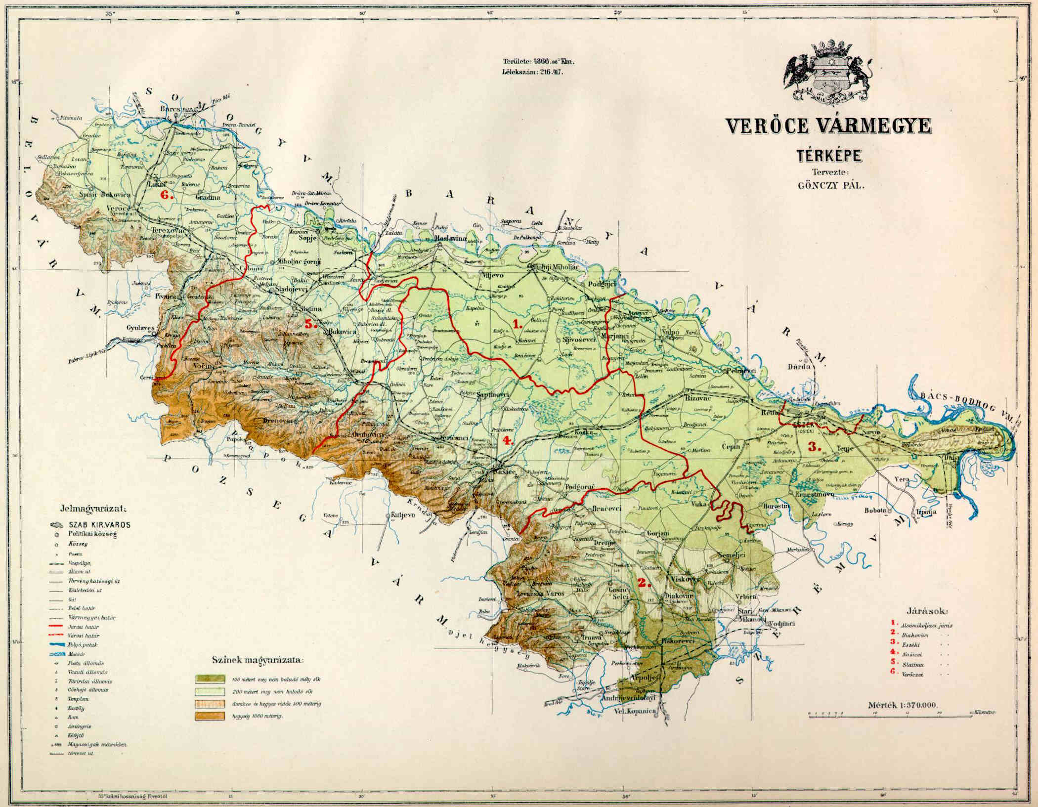
"notes": "https://upload.wikimedia.org/wikipedia/commons/b/b5/Veroce_County_Map.jpg",
"published": false,
"lat": 45.52639,
"lng": 19.06028,
"source": null,
"kind": {
"id": 232,
"label": "https://www.geonames.org/ontology#P.PPLA2",
"url": "https://mpr.acdh.oeaw.ac.at/apis/api/vocabularies/placetype/232/",
"parent_id": null
},
"text": [
{
"id": 3686,
"label": "ID: 3686",
"url": "https://mpr.acdh.oeaw.ac.at/apis/api/metainfo/text/3686/"
}
],
"collection": [
{
"id": 1,
"label": "Default import collection",
"url": "https://mpr.acdh.oeaw.ac.at/apis/api/metainfo/collection/1/"
},
{
"id": 17,
"label": "QHOD",
"url": "https://mpr.acdh.oeaw.ac.at/apis/api/metainfo/collection/17/"
}
],
"sameAs": [
"https://mpr.acdh.oeaw.ac.at/entity/14685/",
"https://sws.geonames.org/3200884/"
]
},
{
"url": "https://mpr.acdh.oeaw.ac.at/apis/api/entities/place/14653/?format=api",
"id": 14653,
"name": "Vukovar",
"review": false,
"start_date": null,
"start_start_date": null,
"start_end_date": null,
"end_date": null,
"end_start_date": null,
"end_end_date": null,
"start_date_written": null,
"end_date_written": null,
"status": "distinct",
"references": "",
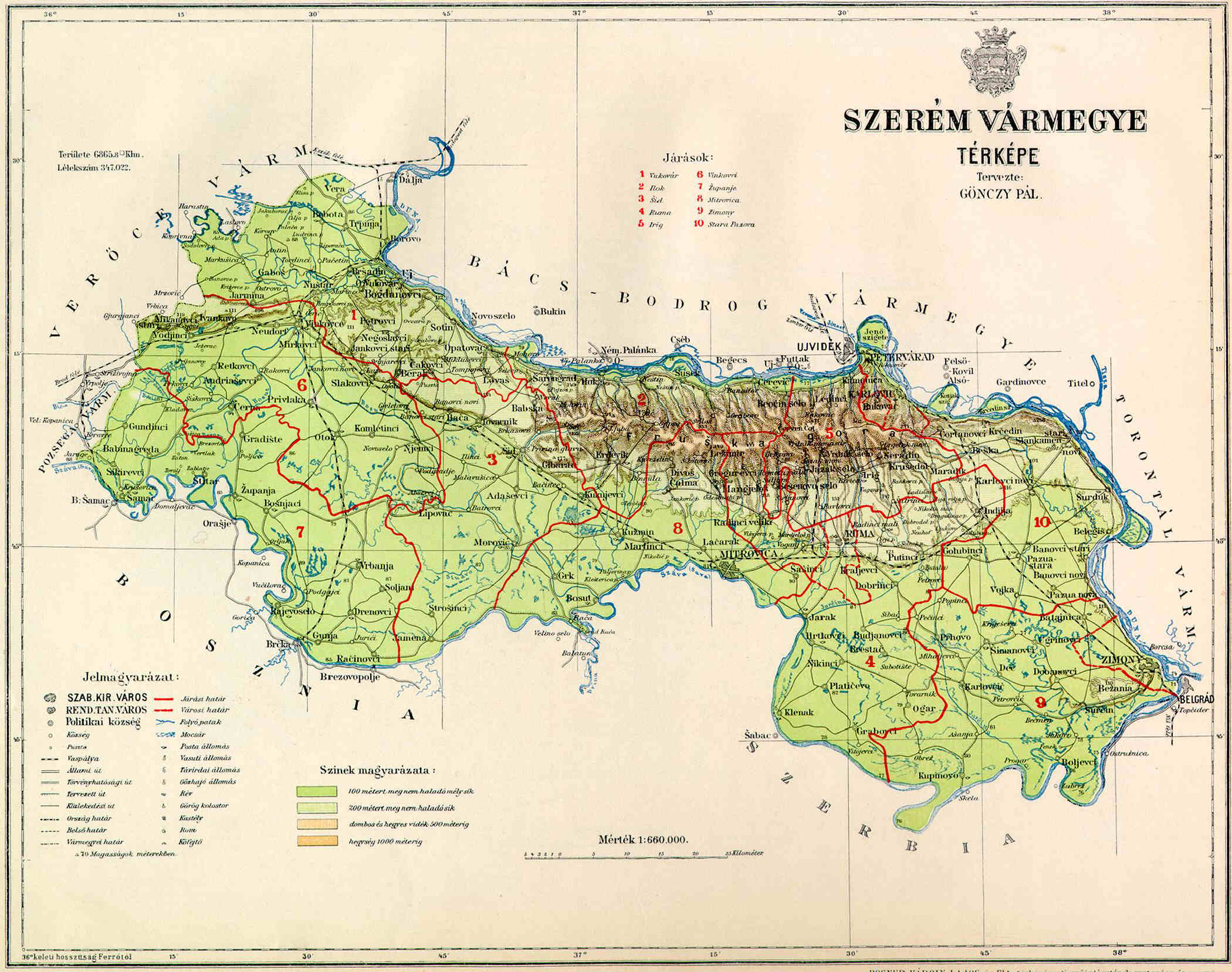
"notes": "https://upload.wikimedia.org/wikipedia/commons/4/4c/Szerem_County_Map.jpg",
"published": false,
"lat": 45.35161,
"lng": 19.00225,
"source": null,
"kind": {
"id": 231,
"label": "https://www.geonames.org/ontology#P.PPLA",
"url": "https://mpr.acdh.oeaw.ac.at/apis/api/vocabularies/placetype/231/",
"parent_id": null
},
"text": [
{
"id": 2655,
"label": "ID: 2655",
"url": "https://mpr.acdh.oeaw.ac.at/apis/api/metainfo/text/2655/"
}
],
"collection": [
{
"id": 1,
"label": "Default import collection",
"url": "https://mpr.acdh.oeaw.ac.at/apis/api/metainfo/collection/1/"
},
{
"id": 17,
"label": "QHOD",
"url": "https://mpr.acdh.oeaw.ac.at/apis/api/metainfo/collection/17/"
}
],
"sameAs": [
"https://mpr.acdh.oeaw.ac.at/entity/14653/",
"https://sws.geonames.org/3187047/"
]
},
{
"url": "https://mpr.acdh.oeaw.ac.at/apis/api/entities/place/14600/?format=api",
"id": 14600,
"name": "Bela Palanka",
"review": false,
"start_date": null,
"start_start_date": null,
"start_end_date": null,
"end_date": null,
"end_start_date": null,
"end_end_date": null,
"start_date_written": null,
"end_date_written": null,
"status": "distinct",
"references": "",
"notes": "https://books.google.at/books?id=io8mDwAAQBAJ&pg=PA231&lpg=PA231&dq=gg+mustafa+pascha+%22palanka%22&source=bl&ots=gJEPiu-uGm&sig=ACfU3U1XF-ESoC6IPid9MSlFTm_eNxfL4g&hl=de&sa=X&ved=2ahUKEwiJv9L2muz2AhV6QvEDHX9EDkAQ6AF6BAgWEAM#v=onepage&q=gg%20mustafa%20pascha%20%22palanka%22&f=false confirms that Akbalanka == Mustafa Pascha Palanka as the place is called in Driesch.",
"published": false,
"lat": 43.21833,
"lng": 22.31111,
"source": null,
"kind": {
"id": 227,
"label": "https://www.geonames.org/ontology#P.PPLA3",
"url": "https://mpr.acdh.oeaw.ac.at/apis/api/vocabularies/placetype/227/",
"parent_id": null
},
"text": [
{
"id": 2569,
"label": "ID: 2569",
"url": "https://mpr.acdh.oeaw.ac.at/apis/api/metainfo/text/2569/"
}
],
"collection": [
{
"id": 1,
"label": "Default import collection",
"url": "https://mpr.acdh.oeaw.ac.at/apis/api/metainfo/collection/1/"
},
{
"id": 17,
"label": "QHOD",
"url": "https://mpr.acdh.oeaw.ac.at/apis/api/metainfo/collection/17/"
}
],
"sameAs": [
"https://mpr.acdh.oeaw.ac.at/entity/14600/",
"https://sws.geonames.org/792784/"
]
},
{
"url": "https://mpr.acdh.oeaw.ac.at/apis/api/entities/place/1398/?format=api",
"id": 1398,
"name": "Ungarn",
"review": false,
"start_date": null,
"start_start_date": null,
"start_end_date": null,
"end_date": null,
"end_start_date": null,
"end_end_date": null,
"start_date_written": null,
"end_date_written": null,
"status": "distinct",
"references": "",
"notes": "habe es als historisches Land in unsere DB einegebeb, aber aus Geonames entnommen, wo es eigentlich als ADM1H enthalten sein könnte, aber als ADM1 PCLI firmiert",
"published": false,
"lat": 47.0,
"lng": 20.0,
"source": null,
"kind": {
"id": 7,
"label": "http://www.geonames.org/ontology#A.PCLI",
"url": "https://mpr.acdh.oeaw.ac.at/apis/api/vocabularies/placetype/7/",
"parent_id": null
},
"text": [
{
"id": 1976,
"label": "ID: 1976",
"url": "https://mpr.acdh.oeaw.ac.at/apis/api/metainfo/text/1976/"
}
],
"collection": [
{
"id": 1,
"label": "Default import collection",
"url": "https://mpr.acdh.oeaw.ac.at/apis/api/metainfo/collection/1/"
},
{
"id": 2,
"label": "Manuell erstellte Entität",
"url": "https://mpr.acdh.oeaw.ac.at/apis/api/metainfo/collection/2/"
},
{
"id": 4,
"label": "manually created entity",
"url": "https://mpr.acdh.oeaw.ac.at/apis/api/metainfo/collection/4/"
},
{
"id": 17,
"label": "QHOD",
"url": "https://mpr.acdh.oeaw.ac.at/apis/api/metainfo/collection/17/"
},
{
"id": 21,
"label": "Import additional Entities 2-21",
"url": "https://mpr.acdh.oeaw.ac.at/apis/api/metainfo/collection/21/"
}
],
"sameAs": [
"http://sws.geonames.org/719819/",
"https://mpr.acdh.oeaw.ac.at/apis/api2/entity/7796/",
"https://sws.geonames.org/719819/",
"https://mpr.acdh.oeaw.ac.at/entity/3011/",
"https://mpr.acdh.oeaw.ac.at/entity/1398/",
"https://mpr.acdh.oeaw.ac.at/entity/7796/",
"https://mpr.acdh.oeaw.ac.at/entity/16590/"
]
},
{
"url": "https://mpr.acdh.oeaw.ac.at/apis/api/entities/place/7558/?format=api",
"id": 7558,
"name": "Jirkov",
"review": false,
"start_date": null,
"start_start_date": null,
"start_end_date": null,
"end_date": null,
"end_start_date": null,
"end_end_date": null,
"start_date_written": null,
"end_date_written": null,
"status": "",
"references": "",
"notes": "Görssau nicht auffindbar in der Gegend der anderen erwähnten Ortschaften, hier ist im Originalprotokoll genau diese Stelle verbrannt und die Lesung verlässt sich auf die masch. Abschrift, \r\n\r\nhttps://mapire.eu/de/map/thirdsurvey25000/embed/?layers=129&bbox=1425391.1934646075%2C6392932.290516743%2C1434482.4225162757%2C6395798.679077437\r\nGossau ist zu weit weg von den anderen Orten um einige Sicherheit in Anschlag bringen zu können…",
"published": false,
"lat": null,
"lng": null,
"source": null,
"kind": null,
"text": [
{
"id": 668,
"label": "ID: 668",
"url": "https://mpr.acdh.oeaw.ac.at/apis/api/metainfo/text/668/"
}
],
"collection": [
{
"id": 13,
"label": "UNFERTIG_ORT",
"url": "https://mpr.acdh.oeaw.ac.at/apis/api/metainfo/collection/13/"
}
],
"sameAs": [
"https://mpr.acdh.oeaw.ac.at/apis/api2/entity/7558/",
"https://mpr.acdh.oeaw.ac.at/entity/7558/"
]
},
{
"url": "https://mpr.acdh.oeaw.ac.at/apis/api/entities/place/14127/?format=api",
"id": 14127,
"name": "Ḫaṭā",
"review": false,
"start_date": null,
"start_start_date": null,
"start_end_date": null,
"end_date": null,
"end_start_date": null,
"end_end_date": null,
"start_date_written": null,
"end_date_written": null,
"status": "distinct",
"references": "Angaben nach Temiz.",
"notes": "früherer Name des Gebietes, das Teile Osttürkistans, Sibiriens, der Mongolei und der Mandschurei umfasst.",
"published": false,
"lat": 46.0,
"lng": 105.0,
"source": null,
"kind": null,
"text": [
{
"id": 2230,
"label": "ID: 2230",
"url": "https://mpr.acdh.oeaw.ac.at/apis/api/metainfo/text/2230/"
}
],
"collection": [
{
"id": 17,
"label": "QHOD",
"url": "https://mpr.acdh.oeaw.ac.at/apis/api/metainfo/collection/17/"
}
],
"sameAs": [
"https://mpr.acdh.oeaw.ac.at/entity/14127/"
]
},
{
"url": "https://mpr.acdh.oeaw.ac.at/apis/api/entities/place/1804/?format=api",
"id": 1804,
"name": "Istrien (Markgrafschaft)",
"review": false,
"start_date": null,
"start_start_date": null,
"start_end_date": null,
"end_date": null,
"end_start_date": null,
"end_end_date": null,
"start_date_written": null,
"end_date_written": null,
"status": "distinct",
"references": "",
"notes": "entspricht als Begriff nicht unbedingt dem Verwaltungsgebit in Cisl.",
"published": false,
"lat": 45.25,
"lng": 13.91667,
"source": null,
"kind": {
"id": 5,
"label": "http://www.geonames.org/ontology#A.ADM1",
"url": "https://mpr.acdh.oeaw.ac.at/apis/api/vocabularies/placetype/5/",
"parent_id": null
},
"text": [],
"collection": [
{
"id": 1,
"label": "Default import collection",
"url": "https://mpr.acdh.oeaw.ac.at/apis/api/metainfo/collection/1/"
},
{
"id": 2,
"label": "Manuell erstellte Entität",
"url": "https://mpr.acdh.oeaw.ac.at/apis/api/metainfo/collection/2/"
}
],
"sameAs": [
"https://sws.geonames.org/3337514/",
"https://mpr.acdh.oeaw.ac.at/entity/1804",
"https://mpr.acdh.oeaw.ac.at/entity/1804/"
]
},
{
"url": "https://mpr.acdh.oeaw.ac.at/apis/api/entities/place/19207/?format=api",
"id": 19207,
"name": "Levante",
"review": false,
"start_date": null,
"start_start_date": null,
"start_end_date": null,
"end_date": null,
"end_start_date": null,
"end_end_date": null,
"start_date_written": null,
"end_date_written": null,
"status": "",
"references": "",
"notes": "Eastern Mediterranean",
"published": false,
"lat": null,
"lng": null,
"source": null,
"kind": null,
"text": [
{
"id": 5178,
"label": "ID: 5178",
"url": "https://mpr.acdh.oeaw.ac.at/apis/api/metainfo/text/5178/"
}
],
"collection": [
{
"id": 17,
"label": "QHOD",
"url": "https://mpr.acdh.oeaw.ac.at/apis/api/metainfo/collection/17/"
}
],
"sameAs": [
"https://mpr.acdh.oeaw.ac.at/entity/19207/"
]
},
{
"url": "https://mpr.acdh.oeaw.ac.at/apis/api/entities/place/17049/?format=api",
"id": 17049,
"name": "Burnu Pamuklu",
"review": false,
"start_date": null,
"start_start_date": null,
"start_end_date": null,
"end_date": null,
"end_start_date": null,
"end_end_date": null,
"start_date_written": null,
"end_date_written": null,
"status": "",
"references": "",
"notes": "Dorf außerhalb von Edirne; existiert heute wahrscheinlich nicht mehr",
"published": false,
"lat": null,
"lng": null,
"source": null,
"kind": null,
"text": [
{
"id": 3789,
"label": "ID: 3789",
"url": "https://mpr.acdh.oeaw.ac.at/apis/api/metainfo/text/3789/"
}
],
"collection": [
{
"id": 17,
"label": "QHOD",
"url": "https://mpr.acdh.oeaw.ac.at/apis/api/metainfo/collection/17/"
}
],
"sameAs": [
"https://mpr.acdh.oeaw.ac.at/entity/17049/"
]
},
{
"url": "https://mpr.acdh.oeaw.ac.at/apis/api/entities/place/15157/?format=api",
"id": 15157,
"name": "Livland (Gouvernement)",
"review": false,
"start_date": null,
"start_start_date": null,
"start_end_date": null,
"end_date": null,
"end_start_date": null,
"end_end_date": null,
"start_date_written": null,
"end_date_written": null,
"status": "distinct",
"references": "https://de.wikipedia.org/wiki/Gouvernement_Livland",
"notes": "Die Koordinaten sind jene der damaligen Hauptstadt Riga",
"published": false,
"lat": 56.9696643657219,
"lng": 24.041259899143906,
"source": null,
"kind": {
"id": 616,
"label": "https://www.geonames.org/ontology#A.ADM2H",
"url": "https://mpr.acdh.oeaw.ac.at/apis/api/vocabularies/placetype/616/",
"parent_id": null
},
"text": [
{
"id": 2820,
"label": "ID: 2820",
"url": "https://mpr.acdh.oeaw.ac.at/apis/api/metainfo/text/2820/"
}
],
"collection": [
{
"id": 1,
"label": "Default import collection",
"url": "https://mpr.acdh.oeaw.ac.at/apis/api/metainfo/collection/1/"
}
],
"sameAs": [
"https://mpr.acdh.oeaw.ac.at/entity/15157/",
"https://d-nb.info/gnd/7577111-1"
]
},
{
"url": "https://mpr.acdh.oeaw.ac.at/apis/api/entities/place/15158/?format=api",
"id": 15158,
"name": "Estland (Gouvernement)",
"review": false,
"start_date": null,
"start_start_date": null,
"start_end_date": null,
"end_date": null,
"end_start_date": null,
"end_end_date": null,
"start_date_written": null,
"end_date_written": null,
"status": "distinct",
"references": "https://de.wikipedia.org/wiki/Gouvernement_Estland",
"notes": "Die Koordinaten sind jene der damaligen Hauptstadt Reval (Tallinn)",
"published": false,
"lat": 59.41122316689691,
"lng": 24.692920569750655,
"source": null,
"kind": {
"id": 616,
"label": "https://www.geonames.org/ontology#A.ADM2H",
"url": "https://mpr.acdh.oeaw.ac.at/apis/api/vocabularies/placetype/616/",
"parent_id": null
},
"text": [
{
"id": 2821,
"label": "ID: 2821",
"url": "https://mpr.acdh.oeaw.ac.at/apis/api/metainfo/text/2821/"
}
],
"collection": [
{
"id": 1,
"label": "Default import collection",
"url": "https://mpr.acdh.oeaw.ac.at/apis/api/metainfo/collection/1/"
}
],
"sameAs": [
"https://mpr.acdh.oeaw.ac.at/entity/15158/",
"https://d-nb.info/gnd/10122295-6"
]
},
{
"url": "https://mpr.acdh.oeaw.ac.at/apis/api/entities/place/15156/?format=api",
"id": 15156,
"name": "Kurland (Gouvernement)",
"review": false,
"start_date": null,
"start_start_date": null,
"start_end_date": null,
"end_date": null,
"end_start_date": null,
"end_end_date": null,
"start_date_written": null,
"end_date_written": null,
"status": "distinct",
"references": "https://de.wikipedia.org/wiki/Gouvernement_Kurland",
"notes": "Die Koordinaten sind jene der damaligen Hauptstadt Miltau (Jelgava)",
"published": false,
"lat": 56.67053310910512,
"lng": 23.741137494897025,
"source": null,
"kind": {
"id": 616,
"label": "https://www.geonames.org/ontology#A.ADM2H",
"url": "https://mpr.acdh.oeaw.ac.at/apis/api/vocabularies/placetype/616/",
"parent_id": null
},
"text": [
{
"id": 2819,
"label": "ID: 2819",
"url": "https://mpr.acdh.oeaw.ac.at/apis/api/metainfo/text/2819/"
}
],
"collection": [
{
"id": 1,
"label": "Default import collection",
"url": "https://mpr.acdh.oeaw.ac.at/apis/api/metainfo/collection/1/"
}
],
"sameAs": [
"https://mpr.acdh.oeaw.ac.at/entity/15156/",
"https://d-nb.info/gnd/4608169-0"
]
},
{
"url": "https://mpr.acdh.oeaw.ac.at/apis/api/entities/place/1435/?format=api",
"id": 1435,
"name": "Cisleithanien",
"review": false,
"start_date": "1867-07-02",
"start_start_date": "1867-01-01",
"start_end_date": "1867-12-31",
"end_date": "1918-07-02",
"end_start_date": "1918-01-01",
"end_end_date": "1918-12-31",
"start_date_written": "1867",
"end_date_written": "1918",
"status": "distinct",
"references": "",
"notes": "die im Reichsrate vertretenen Königreiche und Länder",
"published": false,
"lat": 47.33333,
"lng": 13.33333,
"source": null,
"kind": {
"id": 7,
"label": "http://www.geonames.org/ontology#A.PCLI",
"url": "https://mpr.acdh.oeaw.ac.at/apis/api/vocabularies/placetype/7/",
"parent_id": null
},
"text": [
{
"id": 1093,
"label": "ID: 1093",
"url": "https://mpr.acdh.oeaw.ac.at/apis/api/metainfo/text/1093/"
}
],
"collection": [
{
"id": 1,
"label": "Default import collection",
"url": "https://mpr.acdh.oeaw.ac.at/apis/api/metainfo/collection/1/"
},
{
"id": 2,
"label": "Manuell erstellte Entität",
"url": "https://mpr.acdh.oeaw.ac.at/apis/api/metainfo/collection/2/"
}
],
"sameAs": [
"http://sws.geonames.org/2782113/",
"https://mpr.acdh.oeaw.ac.at/entity/1435/"
]
},
{
"url": "https://mpr.acdh.oeaw.ac.at/apis/api/entities/place/16602/?format=api",
"id": 16602,
"name": "Czopalek",
"review": false,
"start_date": null,
"start_start_date": null,
"start_end_date": null,
"end_date": null,
"end_start_date": null,
"end_end_date": null,
"start_date_written": null,
"end_date_written": null,
"status": "",
"references": "",
"notes": "Czopalek anderthalb stund von der gränitz den 13. Junii 1720\r\n\r\nIrgendwo zwischen Jagodina und Niš",
"published": false,
"lat": null,
"lng": null,
"source": null,
"kind": {
"id": 13,
"label": "http://www.geonames.org/ontology#P.PPL",
"url": "https://mpr.acdh.oeaw.ac.at/apis/api/vocabularies/placetype/13/",
"parent_id": null
},
"text": [
{
"id": 3580,
"label": "ID: 3580",
"url": "https://mpr.acdh.oeaw.ac.at/apis/api/metainfo/text/3580/"
}
],
"collection": [
{
"id": 2,
"label": "Manuell erstellte Entität",
"url": "https://mpr.acdh.oeaw.ac.at/apis/api/metainfo/collection/2/"
},
{
"id": 17,
"label": "QHOD",
"url": "https://mpr.acdh.oeaw.ac.at/apis/api/metainfo/collection/17/"
}
],
"sameAs": [
"https://mpr.acdh.oeaw.ac.at/entity/16602/"
]
},
{
"url": "https://mpr.acdh.oeaw.ac.at/apis/api/entities/place/10891/?format=api",
"id": 10891,
"name": "Ještěd",
"review": false,
"start_date": null,
"start_start_date": null,
"start_end_date": null,
"end_date": null,
"end_start_date": null,
"end_end_date": null,
"start_date_written": null,
"end_date_written": null,
"status": "distinct",
"references": "",
"notes": "created from Pilinkov, coordinates slightly altered",
"published": false,
"lat": 50.72656,
"lng": 15.0383,
"source": null,
"kind": {
"id": 608,
"label": "https://www.geonames.org/ontology#T.MTN",
"url": "https://mpr.acdh.oeaw.ac.at/apis/api/vocabularies/placetype/608/",
"parent_id": null
},
"text": [
{
"id": 2746,
"label": "ID: 2746",
"url": "https://mpr.acdh.oeaw.ac.at/apis/api/metainfo/text/2746/"
}
],
"collection": [
{
"id": 1,
"label": "Default import collection",
"url": "https://mpr.acdh.oeaw.ac.at/apis/api/metainfo/collection/1/"
},
{
"id": 21,
"label": "Import additional Entities 2-21",
"url": "https://mpr.acdh.oeaw.ac.at/apis/api/metainfo/collection/21/"
}
],
"sameAs": [
"https://mpr.acdh.oeaw.ac.at/entity/10891/",
"https://sws.geonames.org/3068312/"
]
},
{
"url": "https://mpr.acdh.oeaw.ac.at/apis/api/entities/place/7319/?format=api",
"id": 7319,
"name": "Vevče",
"review": false,
"start_date": null,
"start_start_date": null,
"start_end_date": null,
"end_date": null,
"end_start_date": null,
"end_end_date": null,
"start_date_written": null,
"end_date_written": null,
"status": "distinct",
"references": "",
"notes": "Bei http://www.biographien.ac.at/oebl/oebl_T/Terpinc_Fidelis_1799_1875.xml fand ich den Zusammenhang zwischen dem Namen Josefsthal und Vevce.",
"published": false,
"lat": 46.05,
"lng": 14.6,
"source": null,
"kind": {
"id": 234,
"label": "https://www.geonames.org/ontology#P.PPL",
"url": "https://mpr.acdh.oeaw.ac.at/apis/api/vocabularies/placetype/234/",
"parent_id": null
},
"text": [
{
"id": 517,
"label": "ID: 517",
"url": "https://mpr.acdh.oeaw.ac.at/apis/api/metainfo/text/517/"
}
],
"collection": [
{
"id": 1,
"label": "Default import collection",
"url": "https://mpr.acdh.oeaw.ac.at/apis/api/metainfo/collection/1/"
}
],
"sameAs": [
"https://mpr.acdh.oeaw.ac.at/apis/api2/entity/7319/",
"https://sws.geonames.org/3187823/",
"https://mpr.acdh.oeaw.ac.at/entity/7319/"
]
},
{
"url": "https://mpr.acdh.oeaw.ac.at/apis/api/entities/place/3020/?format=api",
"id": 3020,
"name": "UNDEF PLACE Parzelle Nr. 572",
"review": false,
"start_date": null,
"start_start_date": null,
"start_end_date": null,
"end_date": null,
"end_start_date": null,
"end_end_date": null,
"start_date_written": null,
"end_date_written": null,
"status": "",
"references": "",
"notes": "<?xml version=\"1.0\" encoding=\"UTF-8\"?>\r\n\r\n-<gpx xmlns=\"http://www.topografix.com/GPX/1/1\" xsi:schemaLocation=\"http://www.topografix.com/GPX/1/1 http://www.topografix.com/GPX/1/1/gpx.xsd\" creator=\"Stadt Wien - http://www.wien.gv.at/\" version=\"1.1\" xmlns:xsi=\"http://www.w3.org/2001/XMLSchema-instance\" xmlns:xsd=\"http://www.w3.org/2001/XMLSchema\">\r\n\r\n\r\n-<wpt lon=\"16.4740362934317\" lat=\"48.2352143672449\">\r\n\r\n<name>1</name>\r\n\r\n</wpt>\r\n\r\n\r\n-<wpt lon=\"16.4747905360418\" lat=\"48.2349138748326\">\r\n\r\n<name>2</name>\r\n\r\n</wpt>\r\n\r\n\r\n-<wpt lon=\"16.4752666765658\" lat=\"48.2344706665315\">\r\n\r\n<name>3</name>\r\n\r\n</wpt>\r\n\r\n\r\n-<wpt lon=\"16.4748806657141\" lat=\"48.2339953374786\">\r\n\r\n<name>4</name>\r\n\r\n</wpt>\r\n\r\n\r\n-<wpt lon=\"16.4745959246\" lat=\"48.2340811159584\">\r\n\r\n<name>5</name>\r\n\r\n</wpt>\r\n\r\n\r\n-<wpt lon=\"16.4743818837696\" lat=\"48.2339290515002\">\r\n\r\n<name>6</name>\r\n\r\n</wpt>\r\n\r\n\r\n-<wpt lon=\"16.4737768811782\" lat=\"48.2341059875139\">\r\n\r\n<name>7</name>\r\n\r\n</wpt>\r\n\r\n\r\n-<wpt lon=\"16.4733363063002\" lat=\"48.2345157038452\">\r\n\r\n<name>8</name>\r\n\r\n</wpt>\r\n\r\n</gpx>",
"published": false,
"lat": 10561.04,
"lng": 344025.56,
"source": null,
"kind": null,
"text": [],
"collection": [
{
"id": 2,
"label": "Manuell erstellte Entität",
"url": "https://mpr.acdh.oeaw.ac.at/apis/api/metainfo/collection/2/"
}
],
"sameAs": [
"http://https://mpr.acdh.oeaw.ac.at/objects/id//apis/api2/entity/3020/",
"https://mpr.acdh.oeaw.ac.at/entity/3020/"
]
},
{
"url": "https://mpr.acdh.oeaw.ac.at/apis/api/entities/place/1416/?format=api",
"id": 1416,
"name": "Venezia",
"review": false,
"start_date": null,
"start_start_date": null,
"start_end_date": null,
"end_date": null,
"end_start_date": null,
"end_end_date": null,
"start_date_written": null,
"end_date_written": null,
"status": "distinct",
"references": "",
"notes": "",
"published": false,
"lat": 45.4389,
"lng": 12.33092,
"source": null,
"kind": {
"id": 10,
"label": "http://www.geonames.org/ontology#A.ADM3",
"url": "https://mpr.acdh.oeaw.ac.at/apis/api/vocabularies/placetype/10/",
"parent_id": null
},
"text": [
{
"id": 2353,
"label": "ID: 2353",
"url": "https://mpr.acdh.oeaw.ac.at/apis/api/metainfo/text/2353/"
}
],
"collection": [
{
"id": 1,
"label": "Default import collection",
"url": "https://mpr.acdh.oeaw.ac.at/apis/api/metainfo/collection/1/"
},
{
"id": 4,
"label": "manually created entity",
"url": "https://mpr.acdh.oeaw.ac.at/apis/api/metainfo/collection/4/"
},
{
"id": 17,
"label": "QHOD",
"url": "https://mpr.acdh.oeaw.ac.at/apis/api/metainfo/collection/17/"
}
],
"sameAs": [
"https://sws.geonames.org/6542284/",
"http://sws.geonames.org/3164603/",
"https://mpr.acdh.oeaw.ac.at/apis/api2/entity/6835/",
"https://sws.geonames.org/3164603/",
"https://mpr.acdh.oeaw.ac.at/entity/9906/",
"https://mpr.acdh.oeaw.ac.at/entity/14233/",
"https://d-nb.info/gnd/4062501-1",
"https://mpr.acdh.oeaw.ac.at/entity/1416/"
]
},
{
"url": "https://mpr.acdh.oeaw.ac.at/apis/api/entities/place/1417/?format=api",
"id": 1417,
"name": "Italien",
"review": false,
"start_date": "1861-07-02",
"start_start_date": "1861-01-01",
"start_end_date": "1861-12-31",
"end_date": "1946-07-02",
"end_start_date": "1946-01-01",
"end_end_date": "1946-12-31",
"start_date_written": "1861",
"end_date_written": "1946",
"status": "distinct",
"references": "",
"notes": "",
"published": false,
"lat": 42.83333,
"lng": 12.83333,
"source": null,
"kind": {
"id": 7,
"label": "http://www.geonames.org/ontology#A.PCLI",
"url": "https://mpr.acdh.oeaw.ac.at/apis/api/vocabularies/placetype/7/",
"parent_id": null
},
"text": [
{
"id": 21,
"label": "ID: 21",
"url": "https://mpr.acdh.oeaw.ac.at/apis/api/metainfo/text/21/"
}
],
"collection": [
{
"id": 1,
"label": "Default import collection",
"url": "https://mpr.acdh.oeaw.ac.at/apis/api/metainfo/collection/1/"
},
{
"id": 2,
"label": "Manuell erstellte Entität",
"url": "https://mpr.acdh.oeaw.ac.at/apis/api/metainfo/collection/2/"
},
{
"id": 21,
"label": "Import additional Entities 2-21",
"url": "https://mpr.acdh.oeaw.ac.at/apis/api/metainfo/collection/21/"
}
],
"sameAs": [
"http://sws.geonames.org/3175395/",
"https://mpr.acdh.oeaw.ac.at/apis/api2/entity/6752/",
"https://sws.geonames.org/3175395/",
"https://mpr.acdh.oeaw.ac.at/entity/1417",
"https://mpr.acdh.oeaw.ac.at/entity/1417/"
]
},
{
"url": "https://mpr.acdh.oeaw.ac.at/apis/api/entities/place/1423/?format=api",
"id": 1423,
"name": "Deutsches Reich",
"review": false,
"start_date": null,
"start_start_date": null,
"start_end_date": null,
"end_date": "1918-01-01",
"end_start_date": null,
"end_end_date": null,
"start_date_written": null,
"end_date_written": "1918",
"status": "distinct",
"references": "",
"notes": "",
"published": false,
"lat": 51.5,
"lng": 10.5,
"source": null,
"kind": {
"id": 7,
"label": "http://www.geonames.org/ontology#A.PCLI",
"url": "https://mpr.acdh.oeaw.ac.at/apis/api/vocabularies/placetype/7/",
"parent_id": null
},
"text": [],
"collection": [
{
"id": 1,
"label": "Default import collection",
"url": "https://mpr.acdh.oeaw.ac.at/apis/api/metainfo/collection/1/"
}
],
"sameAs": [
"http://sws.geonames.org/2921044/",
"https://mpr.acdh.oeaw.ac.at/entity/1423",
"https://mpr.acdh.oeaw.ac.at/entity/1423/"
]
},
{
"url": "https://mpr.acdh.oeaw.ac.at/apis/api/entities/place/1429/?format=api",
"id": 1429,
"name": "Rumänien, Königreich",
"review": false,
"start_date": "1881-07-02",
"start_start_date": "1881-01-01",
"start_end_date": "1881-12-31",
"end_date": "1947-07-02",
"end_start_date": "1947-01-01",
"end_end_date": "1947-12-31",
"start_date_written": "1881",
"end_date_written": "1947",
"status": "distinct",
"references": "https://de.wikipedia.org/wiki/K%C3%B6nigreich_Rum%C3%A4nien",
"notes": "",
"published": false,
"lat": 46.0,
"lng": 25.0,
"source": null,
"kind": {
"id": 7,
"label": "http://www.geonames.org/ontology#A.PCLI",
"url": "https://mpr.acdh.oeaw.ac.at/apis/api/vocabularies/placetype/7/",
"parent_id": null
},
"text": [
{
"id": 15,
"label": "ID: 15",
"url": "https://mpr.acdh.oeaw.ac.at/apis/api/metainfo/text/15/"
}
],
"collection": [
{
"id": 1,
"label": "Default import collection",
"url": "https://mpr.acdh.oeaw.ac.at/apis/api/metainfo/collection/1/"
},
{
"id": 2,
"label": "Manuell erstellte Entität",
"url": "https://mpr.acdh.oeaw.ac.at/apis/api/metainfo/collection/2/"
}
],
"sameAs": [
"http://sws.geonames.org/798549/",
"https://mpr.acdh.oeaw.ac.at/entity/1429",
"https://mpr.acdh.oeaw.ac.at/entity/1429/"
]
},
{
"url": "https://mpr.acdh.oeaw.ac.at/apis/api/entities/place/1436/?format=api",
"id": 1436,
"name": "Kärnten",
"review": false,
"start_date": null,
"start_start_date": null,
"start_end_date": null,
"end_date": null,
"end_start_date": null,
"end_end_date": null,
"start_date_written": null,
"end_date_written": null,
"status": "distinct",
"references": "",
"notes": "",
"published": false,
"lat": 46.75,
"lng": 13.83333,
"source": null,
"kind": {
"id": 5,
"label": "http://www.geonames.org/ontology#A.ADM1",
"url": "https://mpr.acdh.oeaw.ac.at/apis/api/vocabularies/placetype/5/",
"parent_id": null
},
"text": [
{
"id": 1930,
"label": "ID: 1930",
"url": "https://mpr.acdh.oeaw.ac.at/apis/api/metainfo/text/1930/"
}
],
"collection": [
{
"id": 1,
"label": "Default import collection",
"url": "https://mpr.acdh.oeaw.ac.at/apis/api/metainfo/collection/1/"
},
{
"id": 2,
"label": "Manuell erstellte Entität",
"url": "https://mpr.acdh.oeaw.ac.at/apis/api/metainfo/collection/2/"
}
],
"sameAs": [
"https://sws.geonames.org/2774686/",
"https://mpr.acdh.oeaw.ac.at/entity/1436",
"https://mpr.acdh.oeaw.ac.at/entity/1436/"
]
},
{
"url": "https://mpr.acdh.oeaw.ac.at/apis/api/entities/place/1447/?format=api",
"id": 1447,
"name": "Opava",
"review": false,
"start_date": null,
"start_start_date": null,
"start_end_date": null,
"end_date": null,
"end_start_date": null,
"end_end_date": null,
"start_date_written": null,
"end_date_written": null,
"status": "distinct",
"references": "",
"notes": "",
"published": false,
"lat": 49.93866,
"lng": 17.90257,
"source": null,
"kind": {
"id": 13,
"label": "http://www.geonames.org/ontology#P.PPL",
"url": "https://mpr.acdh.oeaw.ac.at/apis/api/vocabularies/placetype/13/",
"parent_id": null
},
"text": [
{
"id": 3115,
"label": "ID: 3115",
"url": "https://mpr.acdh.oeaw.ac.at/apis/api/metainfo/text/3115/"
}
],
"collection": [
{
"id": 1,
"label": "Default import collection",
"url": "https://mpr.acdh.oeaw.ac.at/apis/api/metainfo/collection/1/"
},
{
"id": 21,
"label": "Import additional Entities 2-21",
"url": "https://mpr.acdh.oeaw.ac.at/apis/api/metainfo/collection/21/"
}
],
"sameAs": [
"http://sws.geonames.org/3068927/",
"https://mpr.acdh.oeaw.ac.at/apis/api2/entity/7040/",
"https://sws.geonames.org/3068927/",
"https://mpr.acdh.oeaw.ac.at/entity/10611/",
"https://d-nb.info/gnd/4061019-6",
"https://mpr.acdh.oeaw.ac.at/entity/1447",
"https://mpr.acdh.oeaw.ac.at/entity/1447/",
"https://mpr.acdh.oeaw.ac.at/entity/7040/"
]
},
{
"url": "https://mpr.acdh.oeaw.ac.at/apis/api/entities/place/1450/?format=api",
"id": 1450,
"name": "Adria",
"review": false,
"start_date": null,
"start_start_date": null,
"start_end_date": null,
"end_date": null,
"end_start_date": null,
"end_end_date": null,
"start_date_written": null,
"end_date_written": null,
"status": "",
"references": "",
"notes": "",
"published": false,
"lat": null,
"lng": null,
"source": null,
"kind": {
"id": 615,
"label": "https://www.geonames.org/ontology#H.SEA",
"url": "https://mpr.acdh.oeaw.ac.at/apis/api/vocabularies/placetype/615/",
"parent_id": null
},
"text": [
{
"id": 2790,
"label": "ID: 2790",
"url": "https://mpr.acdh.oeaw.ac.at/apis/api/metainfo/text/2790/"
}
],
"collection": [
{
"id": 3,
"label": "MPR auto regest import",
"url": "https://mpr.acdh.oeaw.ac.at/apis/api/metainfo/collection/3/"
}
],
"sameAs": [
"https://mpr.acdh.oeaw.ac.at/apis/api2/entity/1450/",
"https://mpr.acdh.oeaw.ac.at/entity/1450/"
]
},
{
"url": "https://mpr.acdh.oeaw.ac.at/apis/api/entities/place/1452/?format=api",
"id": 1452,
"name": "Salzburg (Kronland)",
"review": false,
"start_date": null,
"start_start_date": null,
"start_end_date": null,
"end_date": null,
"end_start_date": null,
"end_end_date": null,
"start_date_written": null,
"end_date_written": null,
"status": "",
"references": "",
"notes": "",
"published": false,
"lat": null,
"lng": null,
"source": null,
"kind": null,
"text": [
{
"id": 2012,
"label": "ID: 2012",
"url": "https://mpr.acdh.oeaw.ac.at/apis/api/metainfo/text/2012/"
}
],
"collection": [
{
"id": 3,
"label": "MPR auto regest import",
"url": "https://mpr.acdh.oeaw.ac.at/apis/api/metainfo/collection/3/"
}
],
"sameAs": [
"https://mpr.acdh.oeaw.ac.at/apis/api2/entity/1452/",
"https://mpr.acdh.oeaw.ac.at/entity/1452/"
]
},
{
"url": "https://mpr.acdh.oeaw.ac.at/apis/api/entities/place/1454/?format=api",
"id": 1454,
"name": "Niederländisch-Indien",
"review": false,
"start_date": null,
"start_start_date": null,
"start_end_date": null,
"end_date": null,
"end_start_date": null,
"end_end_date": null,
"start_date_written": null,
"end_date_written": null,
"status": "distinct",
"references": "",
"notes": "",
"published": false,
"lat": -5.0,
"lng": 120.0,
"source": null,
"kind": {
"id": 7,
"label": "http://www.geonames.org/ontology#A.PCLI",
"url": "https://mpr.acdh.oeaw.ac.at/apis/api/vocabularies/placetype/7/",
"parent_id": null
},
"text": [
{
"id": 2617,
"label": "ID: 2617",
"url": "https://mpr.acdh.oeaw.ac.at/apis/api/metainfo/text/2617/"
}
],
"collection": [
{
"id": 1,
"label": "Default import collection",
"url": "https://mpr.acdh.oeaw.ac.at/apis/api/metainfo/collection/1/"
}
],
"sameAs": [
"https://sws.geonames.org/1643084/",
"https://mpr.acdh.oeaw.ac.at/entity/1454",
"https://mpr.acdh.oeaw.ac.at/entity/1454/"
]
},
{
"url": "https://mpr.acdh.oeaw.ac.at/apis/api/entities/place/1468/?format=api",
"id": 1468,
"name": "Lippe, Grafschaft",
"review": false,
"start_date": null,
"start_start_date": null,
"start_end_date": null,
"end_date": null,
"end_start_date": null,
"end_end_date": null,
"start_date_written": null,
"end_date_written": null,
"status": "distinct",
"references": "",
"notes": "",
"published": false,
"lat": null,
"lng": null,
"source": null,
"kind": null,
"text": [
{
"id": 1863,
"label": "ID: 1863",
"url": "https://mpr.acdh.oeaw.ac.at/apis/api/metainfo/text/1863/"
}
],
"collection": [
{
"id": 1,
"label": "Default import collection",
"url": "https://mpr.acdh.oeaw.ac.at/apis/api/metainfo/collection/1/"
}
],
"sameAs": [
"https://d-nb.info/gnd/4099697-9",
"https://mpr.acdh.oeaw.ac.at/entity/1468",
"https://mpr.acdh.oeaw.ac.at/entity/1468/"
]
},
{
"url": "https://mpr.acdh.oeaw.ac.at/apis/api/entities/place/1478/?format=api",
"id": 1478,
"name": "Serbien",
"review": false,
"start_date": null,
"start_start_date": null,
"start_end_date": null,
"end_date": null,
"end_start_date": null,
"end_end_date": null,
"start_date_written": "6. März 1882",
"end_date_written": "1. Dezember 1918",
"status": "distinct",
"references": "",
"notes": "",
"published": false,
"lat": 44.81892,
"lng": 20.45998,
"source": null,
"kind": {
"id": 7,
"label": "http://www.geonames.org/ontology#A.PCLI",
"url": "https://mpr.acdh.oeaw.ac.at/apis/api/vocabularies/placetype/7/",
"parent_id": null
},
"text": [
{
"id": 25,
"label": "ID: 25",
"url": "https://mpr.acdh.oeaw.ac.at/apis/api/metainfo/text/25/"
}
],
"collection": [
{
"id": 1,
"label": "Default import collection",
"url": "https://mpr.acdh.oeaw.ac.at/apis/api/metainfo/collection/1/"
},
{
"id": 2,
"label": "Manuell erstellte Entität",
"url": "https://mpr.acdh.oeaw.ac.at/apis/api/metainfo/collection/2/"
},
{
"id": 17,
"label": "QHOD",
"url": "https://mpr.acdh.oeaw.ac.at/apis/api/metainfo/collection/17/"
},
{
"id": 21,
"label": "Import additional Entities 2-21",
"url": "https://mpr.acdh.oeaw.ac.at/apis/api/metainfo/collection/21/"
}
],
"sameAs": [
"http://sws.geonames.org/6290252/",
"https://mpr.acdh.oeaw.ac.at/entity/9423/",
"https://sws.geonames.org/6290252/",
"https://mpr.acdh.oeaw.ac.at/entity/1478",
"https://mpr.acdh.oeaw.ac.at/entity/1478/"
]
}
]
}